
 Flight Planner, Moving Map and Steak Knives?
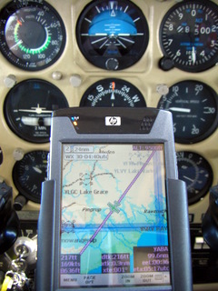
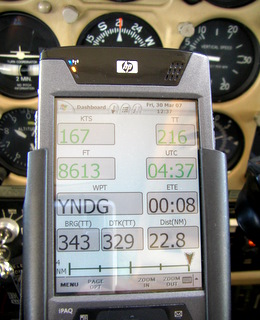
The pockmarked minescape around Kalgoorlie slides by some 8000 feet below. I glance at the small screen cradled on my yoke: it’s reassuring for my passengers (as well as the designated driver!) to see the airplane symbol right on the track to Albany. For a change we have a tailwind as indicated by the wind barbs on the moving map and confirmed by a healthy groundspeed. I check the screen for recent rainfall activity up ahead after having updated the program with the latest Metars and TAFs. It’s time for another radio frequency change to keep in touch with Melbourne Centre as indicated by the passage of a thick blue line across my track on the display.
Life is glorious in the fast lane… and has become a lot easier with the latest release of PocketFMS.
 |
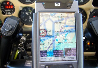 |
Ever since PocketPCs appeared on the scene pilots have been keen to use this mighty tool for flight planning and now also for moving maps. I’ve reviewed most of the existing flight planners in use by the Australian flying fraternity and have yet to come across a program that matches the latest version (v. 0.65) of PocketFMS in the features department and the sheer usability for GA pilots.
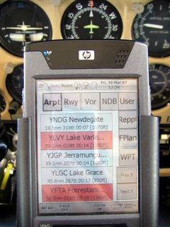
PocketFMS has its roots in Europe and a fair question to ask is: how well are Aussie pilots catered for? Well, it shows that part of the development team is Australian so you can expect not only high resolution maps with elevation data for our region but also over 30,000 searchable place names. Even our quirky NAIPS is integrated.
|
|
Featuring…
Let’s highlight some of the other key features of PocketFMS that sold me on this program:
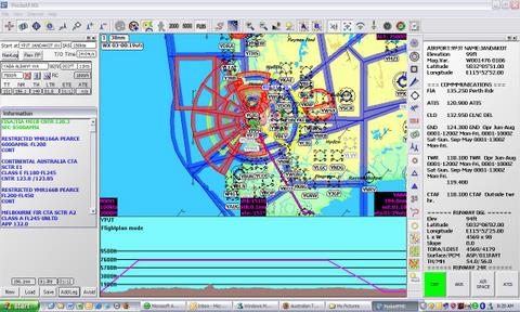
1. The topographical and aeronautical detail on the maps with 10 levels of zoom is unsurpassed. Imagine the same type of ground detail that you find on a VNC or VTC for the major capital cities but then for the whole of Australia!
2. This includes all the airspace boundaries of course but, because PFMS knows exactly where you are in relation to these boundaries, it can give you a timely warning to prevent airspace incursions.
3. The elevation and obstacle data enable you to be warned of terrain ahead.
4. Weather data can be updated even as you fly and is graphically depicted on either one of the two (!) moving maps (you can have a second screen for weather and other reference data to unclutter your main navigation display).
5. 2 hourly(!) aeronautical data updates.
6. The PDA (PocketPC) has the same functionality as the desktop program, meaning you can plan your flight on your home computer, synchronise that plan to your mobile device and make adjustments “on the fly” as needed.
7. The “rubber-banding” functionality makes rerouting extremely easy and the program can even “automagically” get you to avoid certain airspace or track along compulsory reporting points.
8. PocketFMS can be used anywhere in the world with the same features at no further cost.
Initially, you may suffer from information overload as the program is capable of generating massive amounts of data. I wondered how the stuff that filled my 24” desktop monitor would be legible on the 4” display of my PDA? Surprisingly well, actually, as most everything is quickly called up by a quick tap on the touch screen. The user interface is not quite standard as you try to navigate between the screens and menus but it falls into place soon enough.
 |
 |
PFMS has crossed the threshold from “donationware” in the past three years to where the product is solid and valuable enough to warrant an annual subscription of just $240. Mind you, the purchase price is a real bargain: $0. Being a subscriber gives you access to all the data and maps worldwide. And, even though not every region has the same level of map detail as you find in Europe or Australia, it’s easy to scan in your own more detailed charts if you want to. If you don’t own a PocketPC, the desktop part of PFMS as a planner tool is just as worthy of your attention. You can then just print out the relevant maps and nav log and be on your way. PocketFMS is set up as a Foundation, meaning that making profits is not the key motivator. They have a very active user forum with many folk contributing to the program.
Now about those steak knives: yes, there’s more, much more. So for a more detailed look at this program you can visit PocketFMS.com where you can download it and try it out.
We here at DigitalReviews.net will keep you posted on future releases and our experiences with PocketFMS.
