
 Written by Charlie Marraffa
It’s been a long time since I have used CoPilot that came preinstalled on a Windows mobile device several years ago. I had been using the Windows Mobile platform along with various GPS applications that included TomTom, Destinator, IGO8 and others for nearly a decade that all started with the introduction of the HTC XDA.
Today, we are reviewing the latest navigation software from CoPilot: the Live Premium edition, courtesy of the folks at ALK, the creators of CoPilot.
Back in the XDA days, the GPS receivers were initially external hardwired models that progressed to separate Bluetooth receivers as technology advanced. Purchasing the GPS software usually involved an investment of around $600 and were usually beset by a range of other issues and difficulties to get everything working harmoniously.
More recently, I have now migrated to the Android platform when my HTC HD2 was recently stolen in Barcelona. Excluding the $2600 global roaming bill I incurred from its unauthorised use, I can happily say that it was a blessing in disguise. I can’t tell you the number of crashes incurred across every single Windows based phone I had used. The crashes would also usually occur during a phone call or while navigating to a destination.
I was initially apprehensive about moving platforms due to the required learning curve, endless searching for equivalent applications and the dreaded Outlook syncronisation that I use to get my life in order. I do a lot of driving so having this information at all different worksites in conjunction with reliable GPS navigation in order to get there is critical. I then made the courageous leap to Android and in the space of 5 months since my phone was stolen I have migrated from a HTC Desire that prevented me from terminating phone calls due to a faulty proximity sensor that was confirmed as being attributable to faulty hardware after I had flashed it with a new ROM.
I then moved to a Samsung Galaxy S. My intention had been to migrate my existing GPS application (Sygic) to a newly acquired Samsung Galaxy S2. This initial attempt resulted in major stability problems. After reviewing the experiences of others through various forums, I found many had also experienced the same problems using the Galaxy S2 with Sygic and sought an alternative GPS application where I opted for CoPilot. The Galaxy S2 also had a very disappointing, lifeless sound through my Beyerdynamic and Sennheiser headphones with the new Yamaha Digital to Audio Converter (DAC) that Samsung had implemented. I was quite upset when I compared it to the incredible sound emanating from Wolfson DAC in its predecessor that I will now be retaining.
It’s a shame as the Galaxy S2 had the USB port at the base of the phone that allowed easy docking and simultaneous phone charging while driving. This setup would have been perfect for GPS usage and handsfree calling. I still also potentially faced issues with the Galaxy S as it has a GPS receiver that is plagued by reception issues. At times these issues would result in 3-4 minutes to obtain a GPS satellite fix using both Sygic and the pre-installed Navigon that I did not really like. As I now also had Copilot Live Premium and was initially concerned these issues would still occur I pressed ahead on the basis the handset would give me an ideal platform to test the other two applications against Copilot Live Premium to make more informed judgments.
Why have I persisted with this combination using a smartphone and associated GPS application? As you may have guessed, I don’t like carrying a myriad of devices with me. I saw the utility of the smartphone many years ago and have been a vocal proponent and almost geek advocate of their near infinite uses. As they became more powerful and simultaneously cheaper, the masses have also embraced their convenience as evidenced by the surging sales.
Many devices now come pre-loaded with GPS applications, however many of these rely on assisted GPS that uses the mobile data network to speed up and assist with GPS navigation. If you lose mobile reception, the application usually also loses the ability to navigate. The GPS applications I prefer can be configured to solely rely on GPS satellite signals. This eliminates reliance on mobile reception and the affiliated data costs. That’s not to say you will never ever lose satellite reception while driving in a road tunnel or down George St in Sydney with tall buildings flanking you in all directions on a satellite only system.
In order to use GPS navigation successfully, you are now relying on a clear line of sight with the heavens in order to obtain the extremely faint signals emitted by these satellites that are orbiting the earth at significant distances. Imagine trying to listen to music from speakers pumping out 3 watts that are located around 20,000kms away. You usually require a minimum of three satellites for less precise navigating, however you will usually always get a consistent signal reception from 10 to 12 satellites resulting in a high degree of accuracy.
 Installation and Testing
My method of conducting the CoPilot review involves using the application without any user guide review as this allows me to establish how intuitive the application is to new users. My final appraisal then concerns the most fundamental question whether it consistently does what it’s required to – get you there!!!.
I can now give you my impressions concerning CoPilot Live Premium after having used it for two weeks on a near daily basis. I received the email link to Copilot’s application for Android. I then connected my mobile phone to my external modem via Wi-Fi and proceeded to download the APK file on my Galaxy S. I opted for this method as my download quota using my desktop is much greater than my mobile data quota. Once the file had downloaded on to my Galaxy S, I then installed it without any issues.
I was then greeted by Copilot’s welcome screen on my phone prompting me to enter my existing user name and password or create a new one where I opted for the latter. Another small (1.7MB) file was downloaded and installed and once this was completed, the user is then provided with the option of installing the Australian (108MB) or New Zealand maps or both (180MB). Once this has been completed, you can then begin the process of customising the interface to your requirements. When using CoPilot, there’s an abundant range of features and options. I really have only focused on what I believe are pertinent ones for my use and most readers and without resorting to a user manual. For example, there was a fuel prices icon that was greyed out which I presumed was an additional extra and did not pursue any further investigation on.
As always when using a SatNav application, the first thing I do is head straight for the settings. This then allows me to change some of the default settings for the interface to display metric units instead of imperial units, and whether you are alerted when speeding 5, 10, 15, 20 etc kilometers over the speed limit. You may have detected my first critiscm relating to the speed limit warning. We all know the concern that various state authorities in Australia have regarding our safety. We’re also all aware of the very low tolerances imposed for exceeding the speed limit before you are issued that punitive infringement several weeks later. I am sure you can ascertain where my views are currently heading concerning this matter but that’s another debate.
On Sygic, the user has the option to vary when the alerts provided using a slider button for 1km/h increments. It can even be set to warn you if you are under the speed limit, but I don’t understand the relevance of that one.
My user setting in Sygic is set at 0km over the speed limit. In this scenario if I am travelling at 61km/h in a 60km zone, Sygic alerts me. I think this type of setting would have been more appropriate in CoPilot under Australian conditions unless you enjoy contributing to consolidated revenue. I then continued with configuring CoPilot to suit my preferences where I wanted to choose an available voice for the audible instructions. There were only two choices that were either the annoying John or equally annoying US English Pico TTS. This forms the basis of my next critiscm as there should have been an Aussie voice option when the Australian maps were downloaded. CoPilot users can download Jessica who comes up as an Australian option, but I did not investigate further to establish whether this incurred an additional charge as other voices were.
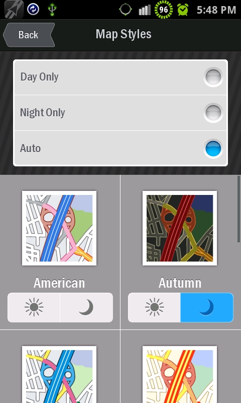
There were still more many more options available. These include map contrasting colors for day and night use. Also, if your device has a light sensor and this option is selected, CoPilot automatically changes the contrast settings to suit the driving conditions.
There’s also volume, screen backlighting and screen orientation options. The user can also choose what and when you would like various points of interests (POI’s) such as nearby banks, petrol stations, etc etc being displayed. I was hoping for the inclusion of speed, traffic, and school zones POI categories in CoPilot. None were found on the default installation as seen below where Safety Cameras are greyed out, however these POI categories can be downloaded at an additional cost.
As the cost of GPS applications has gone down considerably over the years where Copilot Live Premium can now be purchased for $34.99, it’s not too much of a gripe, although I have not investigated the availability, nor how much the additional costs are for these Australian specific options. Some interesting features that I have not encountered on my other GPS applications are the inclusion of social networking options. These include Facebook and Twitter. Although I don’t have an account with either and at this point in time are of no interest to me. They may be for a younger demographic and would require an active data connection.
There’s also an Active Traffic option (upgrade) and another feature that allows you to share your location. CoPilot has also incorporated weather updates in your location, destination or another city. Once again, the use of these would require an active data connection and to an extent are duplicated by other Android specific applications.
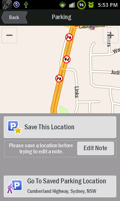
There’s also another very handy feature that allows you to save your parking location. If you’re like me with a limited sense of direction and consumed by thought when exiting your vehicle to the detriment of remembering where you parked the damn car, then I believe you will find this extremely beneficial. Sadly, this feature won’t work in an underground Westfield’s car park for obvious reasons.
Another very useful feature in Copilot was the integration it had with the contacts stored on the phone as opposed to your mobile phone sim contacts. As long as you have an address stored against an existing contact using the correct address fields, you can simply select the navigate to contact option. Copilot will then retrieve the address details and navigate to it, This reduces manual address inputting time.
Many of the other features in Copilot can also be found in various other GPS applications and this includes the transportation options. This allows you to choose whether you’re walking, riding, or travelling by car where it will optimise the route for your transport method. It also includes the ability to avoid toll roads if possible or use them.
An interesting feature that CoPilot has approached in a unique manner is how the user can ascribe further ratings to favour or avoid road categories such as highways, toll roads, primary roads and secondary roads etc. When you select for example, Freeways, another screen is displayed allowing the user the ability to strongly avoid, avoid, neutral, favour and strongly favour. This applies to all road categories. These were left at default during my testing phase, but I will no doubt begin to play around with them in the future to determine how they vary the routes.
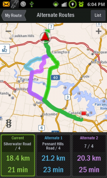
Another feature is the option of editing CoPilot’s proposed route along with being provided three possible route choices to your intended destination. These are displayed in three boxes at the bottom of the screen with additional information concerning the distances of the respective routes along with estimated journey times. As a caveat, if you reside in a congested city like Sydney, these are usually an underestimation. You now simply select your chosen box / preferred route and away you go.
There are many other options in CoPilot and for the purpose of this review, it’s simply not possible to include details relating to all of them. I now wanted to establish a critical fact concerning how long it took to acquire a GPS fix on the Galaxy S. There’s nothing more frustrating having to wait several minutes for a GPS fix before being able to commence your journey as I had become accustomed to when using Sygic.
To my amazement, it was around 30 seconds on first use and around 5 seconds on subsequent uses even after it had not been intentionally used for 1 day. It even gets a satellite fix in my bedroom!!! To elaborate on this point, GPS applications store data concerning your last known location for a short period of time (ephemeris data). Some applications store this data for longer periods than others. The data stored reduces the amount of time that you have to wait before being able to commence your journey waiting for a satellite fix.
The GPS application initially uses this stored data while the GPS receiver begins to acquire new information from the satellite signals to determine your exact current location. This information is then fed to the application for processing to determine your exact starting location. Whether CoPilot stored this data longer, had better control over the communication port, or processed the incoming data more efficiently from the GPS receiver is unknown. I can however conclusively say that initial GPS fixes with CoPilot were significantly faster.
Another thing I appreciated on CoPilot was the clearer and more concise graphical display that would flash up on the screen on complex multi lane roads prior to critical turn off / exit points, I have not included screen shots as I would also need my laptop to capture these while driving. In these situations, the driver has to rapidly process and respond to both visual and audible instructions from the GPS system when navigating. Copilot does it much better with its clear, concise and unambiguous instructions as opposed to Sygic with its confusing array of flashing arrows at the bottom of the screen.
Copilot also has another interesting feature on the Android platform where the user can still view important information in the Android status bar. These include phone reception, battery meter, missed calls, SMS alerts and other alerts. You would have noticed these in the prior screen shots.. In CoPilot, you can also simply slide down the screen and gain access to other Android specific information in the notification area. On Sygic, and Navigon, all the real-estate on the screen is occupied by the GPS application where you have to select the home button and can then move between screens.
I still preferred the menu and confirmation options on Sygic, Whether this preference was solely attributable to the limited exposure and subsequent usage of Copilot or I had become too accustomed to Sygic will be established through Copilot’s continued use. The audible sounds and voice instructions on Copilot were loud and clear. There were several occasions when I questioned CoPilot’s choice concerning the ultimate route it navigated me along. This has at times occurred on every GPS application I have ever used and as far as I am concerned, all roads lead to Rome – at least when in Europe but I am hoping you can see the parallels. In these scenarios, irrespective of what GPS application is used, imagine continually pulling over with your old antiquated street directory and looking up directions as was the case many years ago!!
 Conclusion
My personal appraisal of Copilot relative to the other GPS applications I have used is 8.7/10. None will ever be perfect unless you wrote the code yourself to suit your exact preferences and even then there would still be issues unless you also chose to compile the map data as well. Unlikely!!!
Will I continue using Copilot?
Yes and at the current price of $34.99, it’s a lot better than buying a street directory. As a final rhetorical question, do they still sell street directories??
